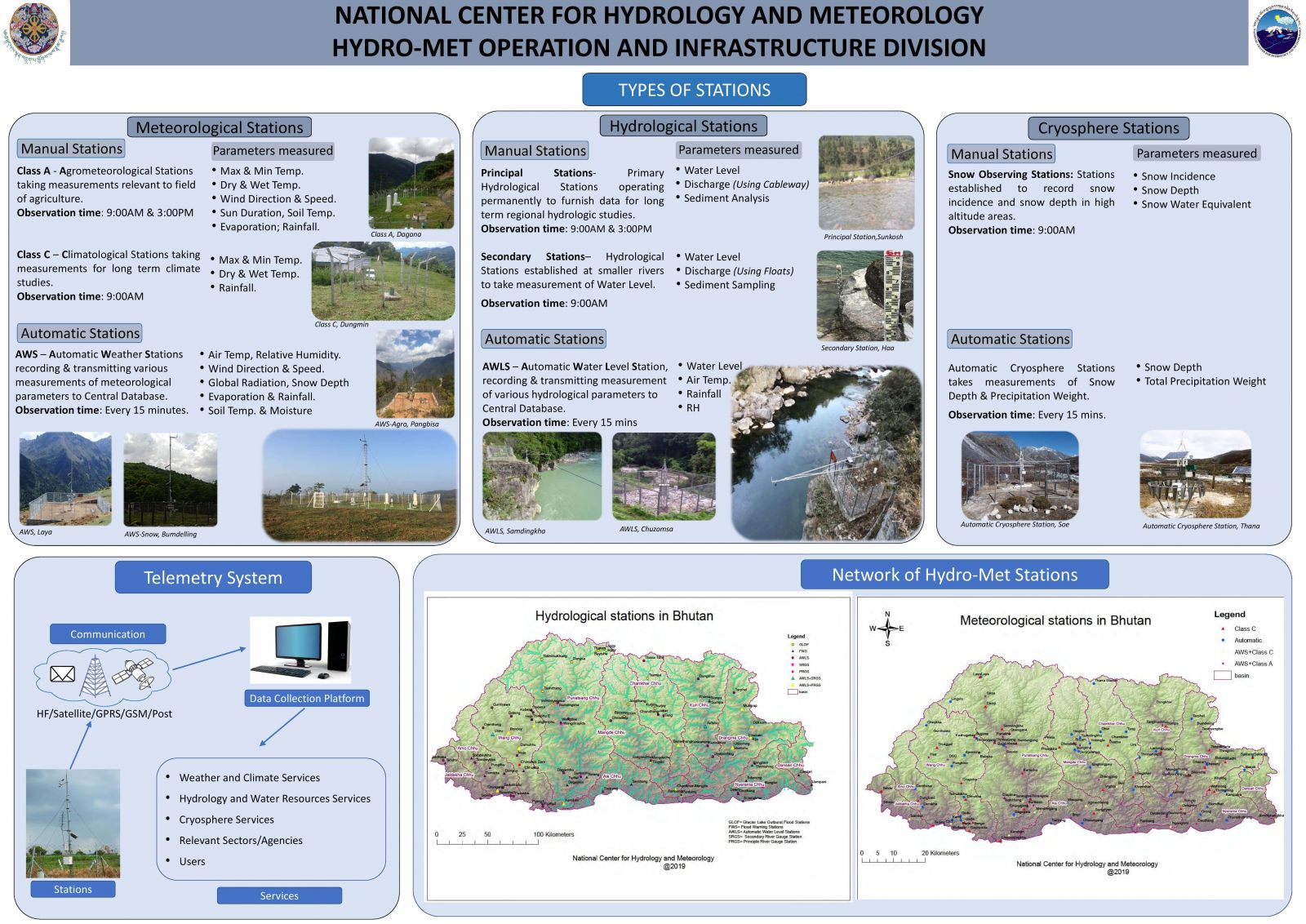
A. Hydrological Stations
The national hydrological monitoring network consists of 22 principal stations and 8 secondary river gauging stations and 45 automatic water level stations located mostly on the north-south running rivres. There are sediment sampling stations that operates in parallel with some of the river gauging stations. Depending on the method used and type of equipment installed at each site, the hydrological stations in Bhutan are broadly divided into the following categories;
1. Principle River Gauging Station (PRGS)
2. Secondary River Gauging Station (SRGS)
3. Automatic Water Level Station (AWLS)
4. Automatic River Discharge Measurement System (ARDMS)
5. GLOF Early Warning Station (GLOF-EWS)
1. Principle River Gauging Station
The station, sometimes called primary stations, are inteded to be operated permanently; in showing time trends they furnish data of importance to regional hydrologic studies. It is an advanced type of station equipped with staff gauges, cableway and winch shed, and electronic water level recorder, full time Gauge and Discharge readers, who take reading of staff at 09.00 and 1500hrs each day.
Discharge measurement is taken from bank operated cableway using a suspended current meter once a week. Water level data and discharge results, after computation, are sent to HQ, Thimphu every month for analysis and archival.
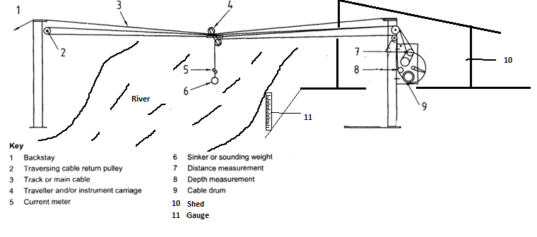
Typical Priciple River Gauging Station
The secondary station, unlike Principal River Gauging Station, is equipped with River Gauge (11), and the discharge is taken using "Float Method".
2. Secondary River Gauging Station
These stations are intended to be operated only long enough to establish the flow characteristics of their watersheds, relative to those of a watershed gauged by a principal, or primary, hydrologic station. The length of time that a secondary hydrologic station is operated is dependent on how well its records correlate with those of a principal station.
A secondary station consists of a set of staff gauges for water level reading. Discharge measurements are taken by using “Traditional Float Method” in which the river cross section for taking float measurements and float distance are taken and set up during the lean season. The staff gauges are read at 09:00hrs every day. Daily discharge measurement is made by observing the tame taken for a set of floats to pass along a known measured length of the river.
3. Automatic Water Level Stations
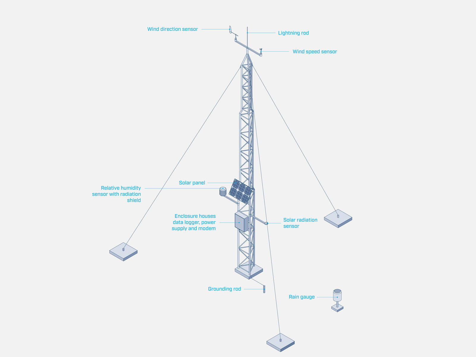
These stations are automatic stream gauging stations equipped with automatic water level sensors, recorders and telemetry system to sense, store and automatically transmit the data to central database. The Water level sensors are either non-contact (radar sensors) or contact (pressure transducer to sense hydrostatic pressure). The data transmission occurs in the interval of 30 mins. In addition the station is equipped with Air Temperature, Relative Humidity and Precipitation Gauge.
4. Automatic River Measurement Stations
These stations are stream gauging stations equipped with river velocity sensors, recorders and telemetry system to transmit the computed discharge data (using the manually keyed cross sectional area and sensed velocity) to the central database. The data tranmission interval is 30 mins.
5. GLOF Early Warning Stations.
The GLOF Early Warning Stations functions the same as AWLS and sends the data to respective control room and central database every 15 mins. These stations are situated at strategic location along the river and at the outlet of Potentially Dangerous Lakes for a particular basin to have sufficient lead time to alert the rising water level to downstream stations and control room.
B. Meteorological Stations
The national meteorological network consists of 20 Class A stations, 62 Class C stations and 85 Automatic Weather Stations. There are also snow monitoring sensors that operates parallel with some of the weather stations. Depending on the parameters observed and data transmision method, the meteorological stations in Bhutan are broadly classified into the following catagories;
1. Climatological stations (Class C)
2. Agrometeorological Stations (Class A)
3. Automatic Weather Stations (AWS)
1. Climatological Stations (Class C)
These are Climatological stations where only the basic meteorological parameters like air temperature (max and min temperature), dry and wet temperature and rainfall is observed and is operated for long time climate analysis. The readings are taken at 09:00 hrs every day the part time observer. In addition, few stations located at high altitude also take snow depth and snow incidence measurement.
2. Agrometeorological Stations (Class A)
These are agrometeorological stations observing agro-related parameters like soil temperature, moisture, evaporation rate, wind direction and speed, relative humidity, sunshine duration and rainfall are observed. The readings are taken at 09:00hrs and 15:00hrs each day by the field staff. The compiled data is sent to Headquarters for archival.
3. Automatic Weather Stations (AWS)
These are automatic stations where the observed meteorological data are sensed, recorded and transmitted to the central database automatically.