


Intergovernmental Panel on Climate Change (IPCC) definition - Climate change in IPCC usage refers to a change in the state of the climate that can be identified (e.g. using statistical tests) by changes in the mean and/or the variability of its properties, and that persists for an extended period, typically decades or longer. It refers to any change in climate over time, whether due to natural variability or as a result of human activity.
United Nations Framework Convention on Climate Change (UNFCCC) definition - Climate change in UNFCCC usage refers to a change of climate that is attributed directly or indirectly to human activity that alters the composition of the global atmosphere and that is in addition to natural climate variability observed over comparable time periods.
Climate change in Bhutan
|
|
| Fig 1. Glacier retreating at an alarming rate. Credit: CSD, NCHM |
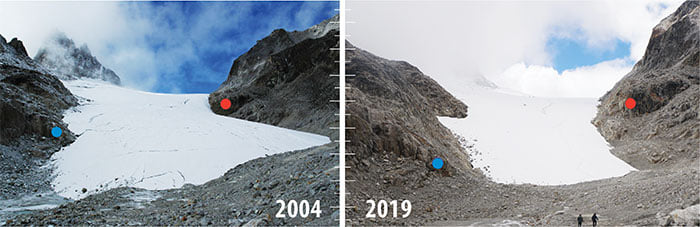
Bhutan’s economy is highly dependent on climate-sensitive sectors such as agriculture, hydropower, and forestry. The most significant impact of climate change in Bhutan is the formation of supra-glacial lakes due to the accelerated retreat of glaciers with increasing temperatures. Other impacts include extreme weather, changing rainfall, drying of streams, and flash floods. The Fifth Assessment Report (AR5) of the Intergovernmental Panel on Climate Change (IPCC) projects an increase of about 4.8 °C in global mean surface temperature by the end of the century. IPCC indicated that much more studies on climate change are required especially at the regional and national levels.
Impact of Climate Change in Bhutan
|
|
About 70 per cent of the country’s land area (38,394 square kilometers) is under forest cover. Even though Bhutan is a net sequester of greenhouse gases (GHG), the effects of climate change and variability are becoming increasingly visible. Precarious geographical location and effects of climate variability and change have highly exposed Bhutan to a diversity of hazards, including cyclone induced storms, flash/floods, landslides, earthquakes, glacial lake outburst floods (GLOF) and droughts. Heavy seasonal monsoon rains and glacial melt are the most common cause of flooding and landslides in Bhutan. Over 70 per cent of settlements (MoWHS, 2017) including infrastructures and fertile agricultural lands are located along the main drainage basins, hence posing threats from flooding.
1) GLOF incidents:
 The country experienced GLOF events in 1957, 1960, 1968 and 1994 (RGOB-WB, 2015). The 1994 GLOF event from Luggye Tsho killed 21 people, damaged 91 houses and 1,781 acres of land. The heavy rainfall brought about by Cyclone Aila in 2009 caused Bhutan to incur an estimated loss of US$ 17 million.
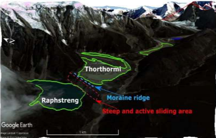
Fig 2. Raphstreng and Thorthormi lakes showing the location of thin and active moraine
2) Prolonged droughts:
The country is also increasingly experiencing prolonged and extreme droughts in parts of the country. This increases the risk of biodiversity loss, forest fires, causes reduction of crop yield and agricultural productivity.
3) Unseasonal rainfall and hailstorms:
 These unpredictable and intense weather events destroy crops and affect farmers who are caught unprepared. Heavy rainfall trigger floods and flash floods are a recurring phenomenon in Bhutan, especially during the summer monsoon. In July 2016, the southern part of the country experienced a flash flood triggered by intense monsoon rainfall displacing more than 100 families and damaging infrastructures.
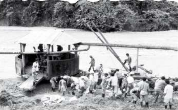
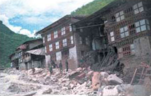
Fig 3. Flash flood in Pasakha (1996) Left, Tashigang (1994) Right
4) Recurrent landslides:
 During the summer monsoon, landslides are a major problem for the roads sector. Roads are vital lifeline for Bhutan as it facilitates transport thereby trade and commerce, and general ease of mobility in and out of the nation.
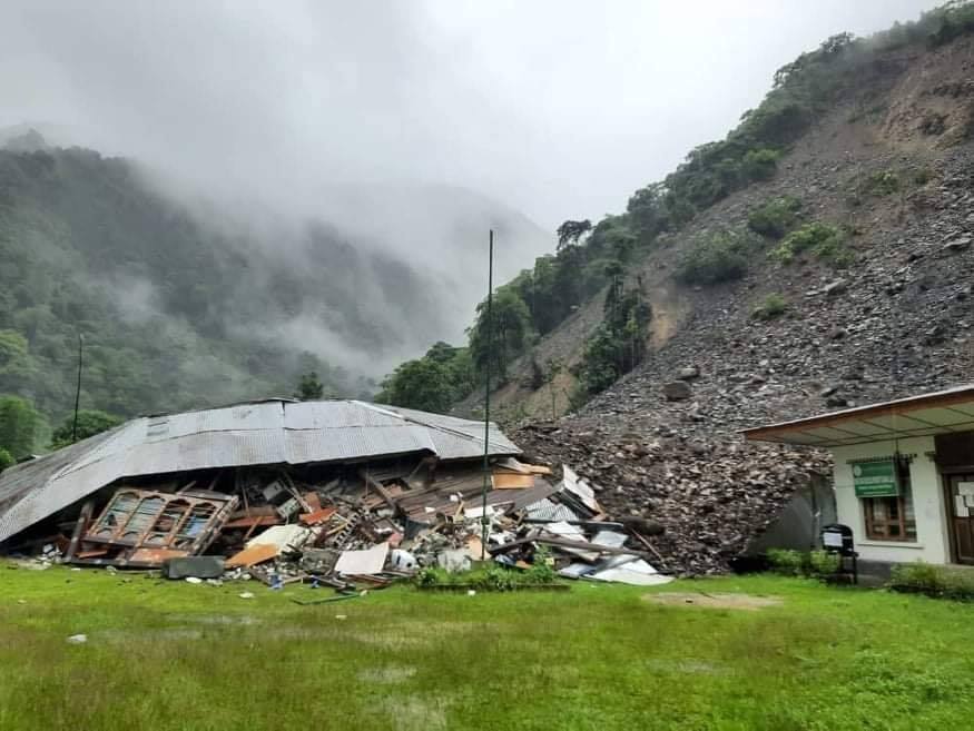
Fig 4. Landslide damages Gomdar office. Source: BBS Facebook page
5) Artificial dams, true dangers:
 Blockage of rivers (most of which are confined in narrow gorges) due to landslides lead to formation of artificial dams. These artificial dams poses great danger to downstream settlements and assets such as hydropower due to landslide dam outburst flood (LDOF). Extreme weather events have significant socio-economic consequences and adversely affect people’s livelihoods and well-being, particularly marginal and poorer communities.
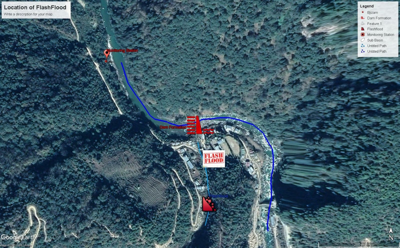
Fig 5. Artificial dam formation in Bjizam 1 Oct, 2020
Climate Control
The climate in Bhutan is mainly controlled by the following factors:
- Topography that varies from low elevation rolling plains of the south to high mountains to the northwest and north of the country.
- Relative distance from the coast, which controls the extent of the moist monsoon current penetration into the country. The eastern regions being closer to the Bay of Bengal are influenced more by the bay current of the Southwest monsoon, much in a similar way as most of Bangladesh and the Northeast India.
- The rainfall regime of Bhutan is controlled by Southwest monsoon circulation that prevails over the Indian sub-continent during summer months. This produces a seasonal cycle with rainy summer seasons over most of the country lasting from June to September. During this part of the year, most of the country has an almost sub-tropical climate, particularly the southern Dzongkhags. Therefore, these areas are prone to dry-spells and drought induced by the variability of monsoon rainfall.
- The control exerted by the dry winter-time air mass from the northern high latitudes during the winter seasons are primarily modulated by what is popularly known as the “western disturbances” bringing a temperate nature to Bhutan’s climate. This also results in temperature variations and the little rainfall/snowfall received during the otherwise dry winters. 2
- Periodic impact by remnants of cyclonic systems that sometimes cross through India from the Bay of Bengal also result in high rainfall events, particularly in the eastern areas. Southernmost areas of the country are prone to severe thunderstorms during the months of April to June due to strong summertime heating and development of strong convective systems. Further north, during the transition months of autumn or spring, such systems can cause damaging hailstorms.
Seasons in Bhutan
Bhutan has four seasons - the winter season from December to February; spring season from March to May; summer season from June to September; and the autumn season of October and November. The Southwest or Summer Monsoon (June-September, JJAS) contributes about 72% to the total annual rainfall of Bhutan with the highest amount received in the month of July followed by August. The spring (March-May, MAM) and autumn (October-November) period contribute about 22 % to the total annual rainfall.